The planet Earth we live on is surrounded by an extremely complex physical environment which is subject to the impact of the Sun activities, the internal processes of the Earth and human activities. Space weather is the result of interaction of the solar wind energy and the thin plasma in geospace (1000 km above the Earth surface). An array of factors lead to deep coupling of global changes and space weather phenomena, such as the Earth's atmosphere up to 1000 km, solar radiant energy, energy released from space weather events, feedback modulation from the Earth surface systems as represented by the ocean cryosphere, and long-term changes in the geomagnetic field which impact the motion and distribution of matter at different time scales. Little is known about how energy from the Sun and the Earth affects the geospace environment, a major global scientific frontier.
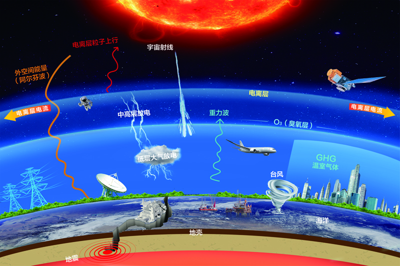
Fig. The Solar-Terrestrial space (driven by solar energy and Earth energy)
The Geospace system is driven by an ever-present flow of energy from the Sun and Earth. The light energy from the Sun maintains the delicate balance in the ecosphere and regulates the tropospheric weather. The magnetic energy from the Sun stirs the often-stormy solar wind through which the Earth sails uneasily. The heat energy within Earth drives tectonic movement and oceanic circulation. The land features of Earth perturb the air circulation and feedback on local and global weathers. All these inputs and interactions account for the high variability of Earth’s climate and weather and are often associated with natural disasters or undesirable long-term trends.
The ionosphere and mid-upper atmosphere (IMUA), located in the altitude range 20- 1000 km, is crucial to Geospace Change. Energy extracted from the solar-terrestrial interaction and energy propagating upward from the troposphere give rise to a complex pattern of motion and turbulence, which can change significantly the distribution of species participating in the chemistry of Global Change. IMUA is also the seat of extreme Space Weather, an electromagnetic meltdown in space posing a major threat to economy and potentially human life. According to a 2008 report by the US National Research Council[1], if the largest recorded space weather incident, the Carrington event in 1859 (when the use of electric power was still a novelty), were to recur today, the potential economic loss could exceed $2 trillion in the US alone, with potential loss in life measured in millions. Moreover, the pattern of IMUA motion and turbulence is a mirror image of their respective solar and terrestrial energy sources, raising the possibility of using IMUA perturbation patterns to predict space weather and Earth-originated disruptions (e.g., earthquake).
Till now we have not understood fully Space Weather or how Global Change responds to energy flows from the Sun and Earth, much less making robust predictions based on the understanding. However, there is a strong foundation to achieve this understanding. Over the years, the scientists have built powerful regional and continent-scale arrays of sophisticated ground-based instruments capable of taking the snapshots of IMUA over a large area. Combined these snapshots gives a fuzzy collage of Geospace, but not a smooth movie.
The goal of the International Meridian Circle Program is to obtain, on a continuous basis, global movie of Geospace in motion, by 1) synchronizing the observations from the existing networks around the globe, 2) harmonizing data formats and analytics standards, 3) building strategically important new research capacities, and 4) establishing an International Meridian Organization to oversee the research and operational activities of the combined global network.
The majority of the existing Geospace-observing networks are distributed along the Great Meridian Circle along the 120° E and 60° W longitudes, cutting across China, Russia, Canada, the United States, Latin America, Antarctica, Australia, and Southeast Asia, with about 1,000 instruments in operation or under construction. In particular, in China, the Chinese Meridian Project (Phase 1 and 2) will deliver, by 2023, the world’s most extensive ground-based Geospace-observing network with more than 300 instruments measuring 38 different parameters.
Once integrated, the 1000 instruments deployed along the 120° E+60° W meridian circle can give a complete cross-sectional scan of Geospace from ground level to up to 3000 km altitude, including density, temperature, electric and magnetic fields, wind fields, planetary waves, and distribution of minor species involved in Global Change. By virtue of Earth’s the rotation, this network can give a complete three-dimensional representation of these key Geospace parameters every 12 hours. Accumulated over years and decades, this dataset will provide valuable insight on how Climate and long-term atmospheric change are influenced by solar and terrestrial energy input. By detecting and tracking short-term anomalies in Geospace parameters, the network can provide advance warnings on space weather and terrestrial disasters such as earthquake.
In addition, with some active European countries leading the way, there is possibility to establish a sub-chain connecting the Europe and the Africa continent, which could reduce the cadence of complete global geospace imaging to 6 hours.


