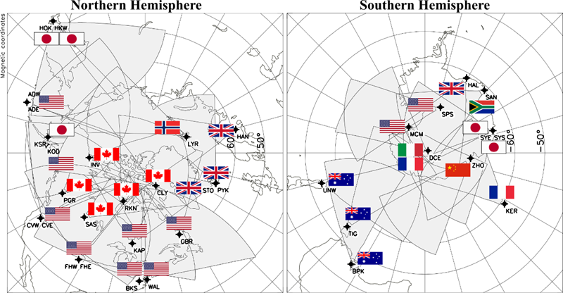
EISCAT
The EISCAT Scientific Association, based in Kiruna, Sweden, is a non-profit scientific organization. Its members include Britain, Sweden, Finland, Norway, Japan and China. The European Union, France, Germany, Russia and Ukraine also provide funding for EISCAT. Its observer states include South Korea and South Africa. Established in 1975, EISCAT conducts research on the lower, middle and upper atmosphere and ionosphere using the incoherent scatter radar technique. This technique is the most powerful ground-based tool for these research applications. The EISCAT aims at coordinating the joint investment of member states in high-power incoherent scatter radars for space weather and space environment observations, and sharing of the instruments, data and scientific research results, so as to improve the understanding of space weather processes and strengthen joint research on space physics in arctic. In ground-based observation and detection, EISCAT always plays a leading role in radar detection technology, providing high quality detection data to scientific institutions in Europe and around the world for the past 30 years.
SuperDARN
SuperDARN(The Super Dual Auroral Radar Network) stands for Super Dual Auroral Radar Network. SuperDARN is an international network of high- frequency (HF) radars for researching the Earth’s upper atmosphere and ionosphere.
The principle backscatter targets are plasma irregularities with decameter spatial scales. The network consists of more than 30 low-power HF radars that look into Earth's upper atmosphere beginning at mid-latitudes and extending into the polar regions. The radars operate continuously and observe the motion of charged particles (plasma) in the ionosphere and other effects that provide scientists with information on Earth's space environment. The knowledge gained from this work provides insight into space weather hazards including radiation exposure for high-altitude travelers and disruptions to communication networks, navigation systems (GPS), and electrical power grids.
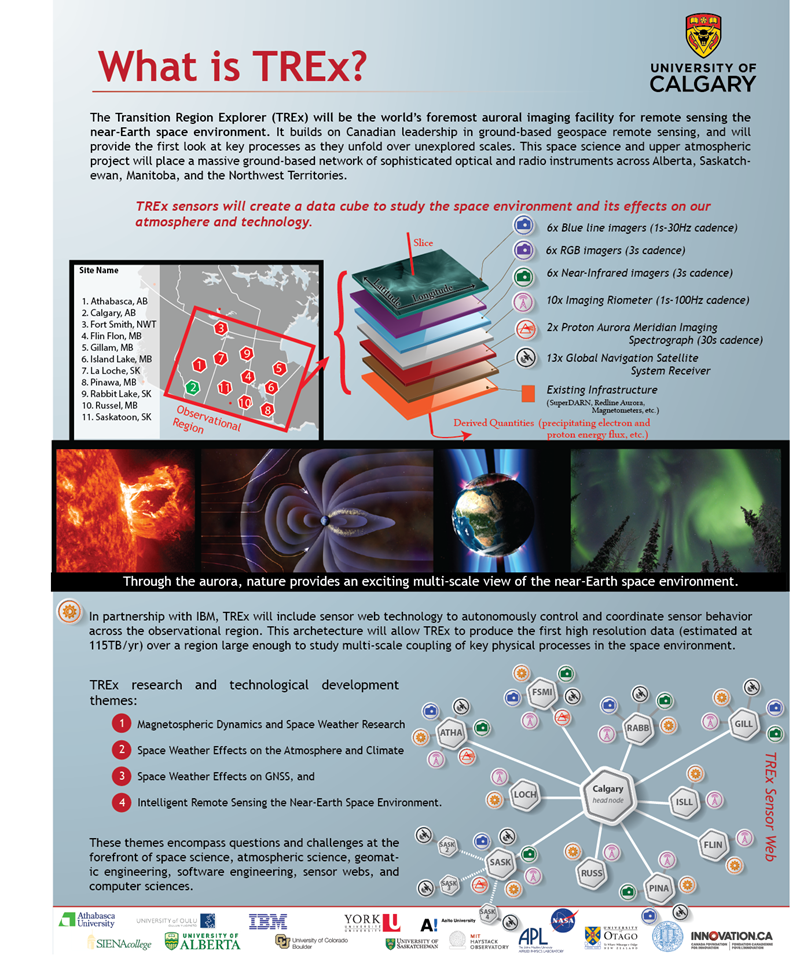
Transition Region Explorer
Transition Region Explorer (TREx) is a CFI-funded project and aims to be the world's foremost auroral imaging facility for remote sensing the near-Earth space environment. The project consists of the development and deployment of an extensive ground-based network of sophisticated optical and radio instrumentation across Alberta, Saskatchewan, Manitoba, and the Northwest Territories.
The TREx project will design and deploy the following instruments:
6 blue-line all-sky imagers (3s-30Hz cadence)
6 RGB color all-sky imagers (3s cadence)
6 Near-Infrared all-sky imagers (6s cadence)
10 Imaging Riometers (1s-100Hz cadence - operations project is GO-IRIS)
2 Proton Aurora Meridian Imaging Spectographs (15s cadence)
13 Global Navigation Satellite System receiver systems (GNSS)
In partnership with IBM, TREx will include sensor web technology to autonomously control and coordinate sensor behavior across the observational region. This architecture will allow TREx to produce the first high resolution data (estimated at 120 TB of data per year) over a region large enough to study multi-scale coupling of key physical processes in the space environment.
Canadian High Arctic Ionospheric Network, CHAIN
The Canadian High Arctic Ionospheric Network (CHAIN) is a distributed array of ground-based radio instruments located in the Canadian High Arctic. The CHAIN instruments are 25 high data-rate GNSS Ionospheric Scintillation and Total electron content monitors (GISTM) and 6 Canadian Advanced Digital Ionosondes. Most of these instruments have been sited within the polar cap (a region of open magnetic field lines).
CHAIN was established in response to the fundamental need for a greater understanding of planetary environments that are affected by short and long term variability of solar output. The Sun-Earth system is a vast coupled system where many physical processes take place, with solar variability driving the terrestrial and space environments. A complete understanding of this complex system requires knowledge about the individual physical processes taking place in the system and in turn necessitates observations. Through the construction and operation of CHAIN, we seek to understand the individual physical processes necessary for the fundamental understanding of the solar-terrestrial coupling and its influence on our planetary environment.
Scientific Objectives of CHAIN
Most of the time, the polar cap ionosphere, a region of open field lines, is directly coupled to the solar wind and interplanetary magnetic field. Mass and energy derived from the interaction are transported across the polar cap and are directly controlled by the variability of solar input (both particle and electromagnetic). Because of this coupling, the polar cap ionosphere is often comprised of ionization and electromagnetic structures. Understanding the polar cap ionosphere will go a long way towards understanding the Solar Wind-Magnetosphere-Ionosphere coupling. The CHAIN scientific objectives are aimed at understanding these polar cap processes. Broad-based scientific objectives of CHAIN are the understanding of:
·Drivers and variabilities of polar cap convection
·Generation and dynamics of ionization structures in the polar cap
o Macroscale – Tongue of ionization (>1000 kms)
o Mesoscale – Polar patches (Few hundred kms)
o Microscale – Scintillation producing structures (Few kms)
·Role of ionosphere in Magnetosphere-Ionosphere (M-I) coupling
·Improve handling/modeling of effects on Global Navigation Satellite Systems (GNSS)
The basic CHAIN measurements, relevant to these scientific objectives, are the 30s resolution measurement of the convection and one minute resolution measurement of the ionograms at the 6 CADI locations, and GNSS-based measurements of TEC and scintillation at 25 stations (50 Hz sampling). One important and unique factor regarding CHAIN is that 6 of the 25 GPS receivers are collocated with ionosondes. This configuration will allow us to perform more realistic 4D (three spatial dimensions plus time) tomographic inversions of the ionosphere using the Multi-Instrument Data Analysis System (MIDAS) for addressing some of the scientific objectives.


